
GPS-rajzolás
Bringával és futva "rajzolt" GPS útvonalaim (egytől egyig saját ötlet). A GPS-rajzok Gyöngyös városban készültek.
GPS drawings - to draw pictures on street maps with GPS
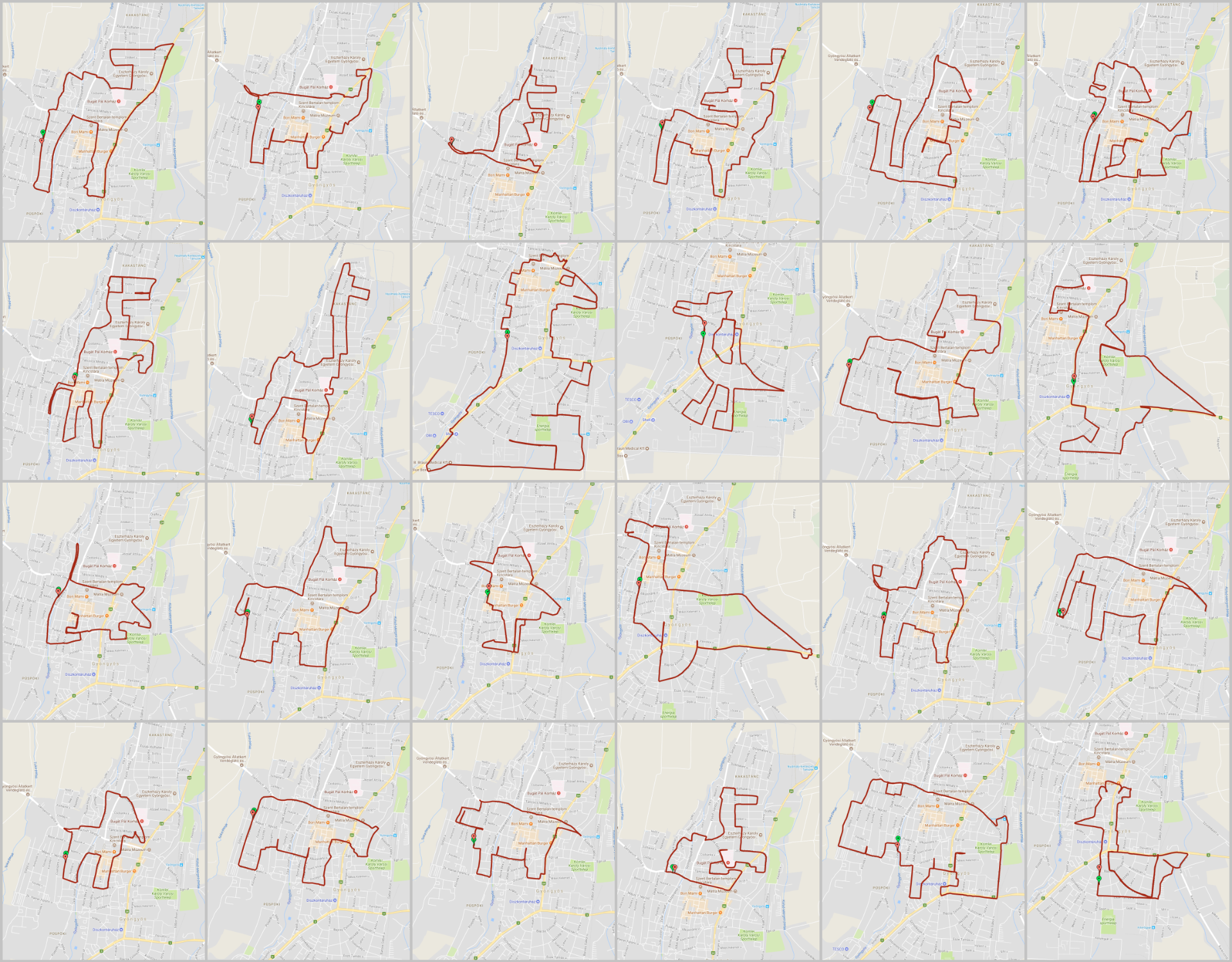
My name is Mariann Holló, I started drawing with GPS in December 2015. While I am riding my bicycle or running, I'm also drawing something... Using GPS bike computer tracking to trace my routes throughout the city or in a field and forming them into different animals shape or interesting figures that become detailed pictures. I made the GPS drawings in a small town called Gyöngyös in Hungary. Area of Gyöngyös: 55,31 km². Adding up my GPS drawings so far, I have already drawn more than 1400 kilometers in this city.
by Garmin | Copyright © Holló Mariann

Making fitness fun! Plan your track on map first with a route planner. You need is a GPS watch or a fitness tracker on your smartphone to record track. Then go for a bike ride, run or walk. Your moving track becomes art. Be creative and have fun!


Az első GPS-rajzos animációm <> My first GPS drawing animation
Ez a vicsorgó oroszlánfej már a hetedik GPS-rajz animációm (Hanggal nézd de ne ijedj meg!) <> This snarling lion's head is my 7th GPS art animation (Watch with sound but don't be scared!) 🦁
Futás egy szántóföldön <> Running in a plough field (3D video from my GPX track)
Bringás GPS-rajzolás a város utcáin <> GPS drawing with my bike on the streets of the city (3D video from my GPX track)

Külföldön készült GPS-rajzaim
Utóbbi időben külföldi nyaralásaim alatt is megpróbálkoztam GPS-rajzolással. Persze egy idegen országban, ismeretlen helyen jóval nehezebb tájékozódni, mint a már megszokott környezetben.

A "rajzoláson" túl
Természetesen a GPS-rajzoláson kívül komolyabb biciklitúrákat is szoktam teljesíteni. Imádom a Mátrát. Ha időm engedi, évente többször is letekerem a 80 km hosszú nyugati és keleti Mátra kört. De sokszor teljesítettem már a Gyöngyös - Kékestető csúcstámadást is. Szeretem a kihívásokat. Eddig kétszer tekertem körbe fél nap alatt a Balatont, először 2021-ben és most négy évvel később 2025-ben. A négy évvel korábbi Balaton kerüléshez képest, 33 perccel javult a mozgásidőm, 2 óra 9 perccel pedig a teljes időm. Tehát sokkal kevesebbet kellett pihennem, sokkal jobban ment a tekerés. Valószínűleg ezt a fejlődést is a GPS-rajzolásnak tudhatom be, mivel a nyári hőségben és a téli mínuszokban is folyamatos mozgásra késztet.

Teljes Mátra kör bringával – a Bükktől a Cserhátig és ami közte van!
Az egynapos bringatúra hossza összesen: 126 km, magasságnövekedés: 1507 méter, hőmérséklet 28 és 39 ℃ között.

Fél nap alatt a Balaton körül egy mountain bike-kal
Mivel szeretem a kihívásokat, 4 év után, újra körbetekertem a Balatont. Ahhoz képest, hogy nagyjából az utolsó 70 kilométeren eléggé fújt a szél, több mint fél órát javult a mozgásidőm és természetesen a teljes időm is.